

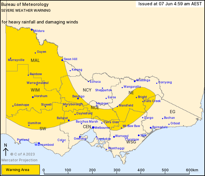
Severe Weather Warning for HEAVY RAINFALL and DAMAGING WINDS for people in the Mallee and parts of the Riverland forecast districts.
Heavy rain developing in the west, damaging wind on higher terrain from this morning.
Weather Situation: A cold front currently moving through South Australia is generating thunderstorms in western Victoria this morning which will become areas of thundery rain throughout the day. North to northwesterly winds will increase across elevated terrain as the front approaches, spreading east into the central ranges by the late morning and into the northeast by later in the evening.
HEAVY RAINFALL which may lead to FLASH FLOODING is forecast for the Mallee, Wimmera and South West districts this morning, spreading into the central ranges during the afternoon and into the northeast during the evening. Six-hourly rainfall totals of 40 to 60 mm are possible, with isolated falls of 70 to 100 mm possible over 24 hours. The heaviest falls are likely to be associated with thunderstorm activity and on higher terrain around the Grampians.
Heavy rainfall is expected to contract east into central districts during the afternoon and into the northeast during the evening.
DAMAGING NORTHERLY WIND GUSTS of 90 to 100 km/h are likely to develop over the Grampians during the early morning before shifting east into into the central ranges later this morning. DAMAGING WIND GUSTS are also possible about the alpine areas in the northeast during the evening.
Severe thunderstorms are also possible across western Victoria during Wednesday afternoon. A separate Severe Thunderstorm Warning will be issued if severe thunderstorms are detected.
A flood watch has also been issued for parts of the state, see: http://www.bom.gov.au/vic/warnings/
The State Emergency Service advises that people should:
* If driving conditions are dangerous, safely pull over away from trees, drains, low-lying areas and floodwater. Avoid travel if possible.
* Stay safe by avoiding dangerous hazards, such as floodwater, mud, debris, damaged roads and fallen trees.
* Be aware – heat, fire or recent storms may make trees unstable and more likely to fall when it’s windy or wet.
* Check that loose items, such as outdoor settings, umbrellas and trampolines are safely secured. Move vehicles under cover or away from trees.
* Stay indoors and away from windows.
* If outdoors, move to a safe place indoors. Stay away from trees, drains, gutters, creeks and waterways.
* Stay away from fallen powerlines – always assume they are live.
* Be aware that in fire affected areas, rainfall run-off into waterways may contain debris such as ash, soil, trees and rocks. Heavy rainfall may also increase the potential for landslides and debris across roads.
* Stay informed: Monitor weather warnings, forecasts and river levels at the Bureau of Meteorology website, and warnings through VicEmergency website/app/hotline.
Image: https://pixabay.com/photos/lightning-thunderstorm-super-cell-2568381/


